
Molave typhoon has yet to come to Vietnam but the country already suffered, with two fishing boats in Binh Dinh sank and 26 fishermen went missing.
On the evening of October 27, Binh Dinh province’s Steering Committee for Disaster Prevention and Search and Rescue said that two ships of this province sunk when moving to avoid Molave typhoon.
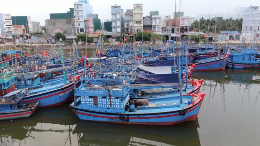
At around 4.30 pm of October 27, the 97469 TS fishing boat of Mr. Vo Ngoc Doan (in Hoai Hai commune, Hai Nhon town, Binh Dinh) who is also its captain, with 14 employees, sunk while strived to seek for shelter to avoid the storm.
Before that, the 96388 TS fishing boat of Mr. Le Van’s (in Hai Thanh ward, Hai Nhon town) was on his way to Cam Ranh port (Khanh Hoa) to avoid storms, was destroyed and sank at 1 pm of the same day, 12 fishermen on this ship are missing.
In this very critical situation, there was no press mention of using helicopters to save lives. On October 26 at the online meeting directing storm response, Prime Minister Nguyen Xuan Phuc said he would mobilize helicopters to save lives, many domestic newspapers reported.
The Titanic Planet Facebook page, specializing in climate and weather research and forecasting, makes the following forecast:
The following is our forecasts in case the power and telecommunications cuts in Binh Dinh, Quang Ngai, Quang Nam, and Danang provinces.
From 1 am to 4 am of October 28, the torrential rain circulation of the super typhoon MOLAVE will hit Binh Dinh to Danang. After 4 am, the rain is probably calm, while in Quang Ngai, Quang Nam, Danang and Hue it will last until 10 am.
Hurricane winds will follow, around 3 am- 4 am will begin hitting the highest level, hissing until 10am. This is the most dangerous time. Flood water may rise after that, but the wind will knock and sweep away many green trees, corrugated iron roofs, tiles, and low houses.
The storm epicenter will go to Quang Ngai city around 6 am- 7 am.
It will be a really powerful storm
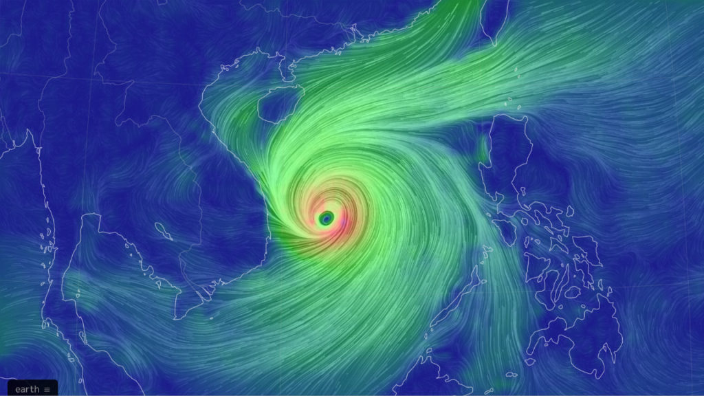
At 4 pm of October 27, storms tend to speed up a little: travel speed 21-24km/h in the West – Northwest Northwest direction.
Based on aerial image from Japanese satellite Himawari-8, taken at 4 pm of October 27 (Vietnam time). The eye of the storm is far from Qui Nhon City 330km to the East, and from Quang Ngai city 391 km to the southeast.
Wind speed at the storm epicenter forecast at 185km/h
Forecast the destruction power of Molave storm: crazy, extremely dangerous
The storm is expected to go through Quang Ngai city
Expected time to occur: 5 am – 6 am of Oct 28
Extremely dangerous zones: Binh Dinh, Quang Ngai, Quang Nam, Danang
Forecast about wind speed and rain volume when Molave hits the central region
Area No. 1. The area where the storm’s center passes and the area 100km away from the storm epicenter:
– Including: Binh Dinh, Quang Ngai, Quang Nam.
– Expected time to be affected: from the evening of October 27 to noon on October 28
– Expected time of the storm’s landing: dawn on October 28

– Wind power: over 150km/h, 180km/h. Assessment of the impact of the wind: destructive winds, terrible destruction.
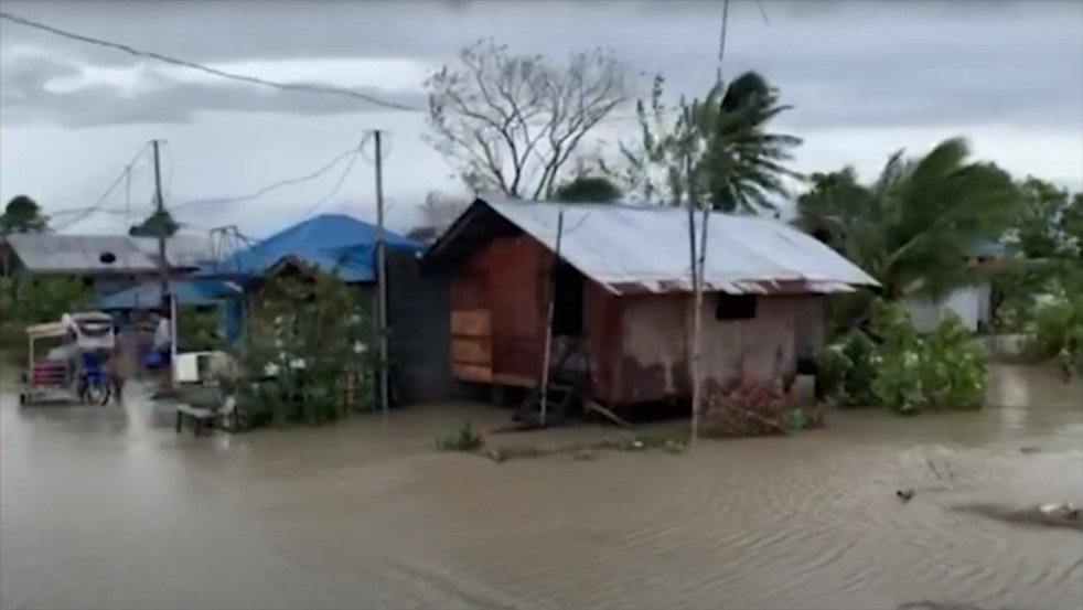
– Rainfall: heavy rains start in each batch, starting from the evening of October 27, continuous torrential rain from dawn to noon on October 28. Rainfall during the whole period: 800 mm-1m.
– Waves are over 10m high.
Area 2. The area to the North of the center of the storm makes landfall, more than 100 km from the storm epiccenter and the radius of 200km from the epicenter:
– Including: Danang and Hue.
– Expected time to be affected: from the evening of October 27 to noon on October 28.
– Wind power: 110-130 km/h. Assessment of the impact of wind: intense, very strong, can destroy rudimentary level 4 buildings.
– Rainfall: moderate to heavy rain in waves from the evening of October 27, torrential rain for 3-4 hours in the morning of October 28. Rainfall during the whole period: 400 mm-600 mm.
– Waves are over 7m high.
Area 3. The area to the south of the storm epicenter makes landfall, more than 100 km from the epicenter and the radius of 200 km from the storm epicenter:
– Including: Phu Yen and Nha Trang.
– Expected time to be affected: from the evening of October 27 to noon on October 28.
– Wind power: from 80-90km/h, may rise to 110km/h. Identify the impact of wind: storm winds, can blow up the big stump.
– Rainfall: moderate to heavy rain in waves from the evening of October 27, heavy rain within the first 1-2 hours of the morning on October 28. Rainfall during the whole period: 100 mm- 200 mm.
– Waves are high from 2-3 meters.
Area 4: The area to the west after the storm makes landfall 1-2 hours, on the way through the center of the storm when going inland:
– Including: Buon Ma Thuot, Pleiku, and Kon Tum.
– Expected time affected: early morning to late afternoon on October 28
– Wind power: from 80-90 km/h and may rise to 110km/h. Identify the impact of wind: storm winds, can blow up the big stump.

– Rainfall: moderate to heavy rain in waves from the evening of October 27, torrential rain for 3-4 hours in the morning of October 28. Rainfall during the whole period: 400 mm-600 mm.
Area No. 1. The area to the North of the storm epicenter makes landfall, more than 200 km from the center of the storm and the radius of over 400 km from the epicenter
– Including: Quang Tri, Quang Binh, and Ha Tinh.
– Expected time affected: the morning of October 28 to the end of October 31
– Wind power: from 50-60 km/h. After the storm makes landfall in the southern part of Central Central, the northeast monsoon will be activated and continue to intensify here, strong seas.
– Rainfall: medium to heavy rain in waves. Heavy rains concentrated in the western regions of Ha Tinh provinces to Quang Binh from the evening of October 28 to the end of October 29.
– Waves are high from 2-3m.
Recommendation
– People in the No.1 areas should go immediately. This storm can be very devastating if you are located in the area of the storm’s epicenter. People have 24 hours to prepare to evacuate if they feel they cannot cope with a storm.
– When Molave storm come, tide levels are still high so areas No. 1, 2 and 3 will have flood as the water cannot go to the sea.
– Fishermen in the whole central region are not allowed to go to sea. From today, boats in the area from Quang Nam to Hue have to come ashore, anchored in an estuary or good wind/breakwater bay.
– Absolutely not stay on the fishing raft when the storm hits. Absolutely do not stay on cliffs, low-lying areas and coastal areas when storms land.
– For thick concrete houses with good foundations, use sand bags, water bags, large steel wire to ballast or tie corrugated iron or tiled roofs. Stick windows and doors with X-shaped tape for each frame. Seal any openings that are coming from your home. Absolutely closed when the storm’s mind hits and passes. Stay away from glass doors.
– Absolutely not stay in low houses, rudimentary, prefabricated houses. Evacuate to shelter with thick concrete walls, good foundations, and well-bred roofs.
– Evacuate and do not stay in low or low areas, where flash floods have occurred before. Bring furniture and valuables to the area as high as possible.
– Evacuate from the places prone to landslides.
– Due to heavy rainfall and fast floods, aquaculture farmers should be prepared for the risk that fish, shrimp, and aquatic animals will be shocked by the sudden drop in seawater salinity. The cage should be moved away from the shore, lower the cage further, and anchor the cage firmly. People should harvest agricultural products and seafood early before the storm comes.
– Hydropower plants from Quang Nam to Khanh Hoa should discharge less stored water in the reservoir to cut floods or reduce the severity of floods after the storm enters.
– Local authorities from Binh Dinh to Quang Nam need to prepare a detailed and professional rescue plan, as well as forecast possible risks to effectively rescue when something happens. This is a big storm, it’s not to be taken lightly.
– Urban areas should prune tree branches, lower billboards, clear drainage sewers to reduce damage caused by local inundation caused by heavy rains. Electric poles are also at risk of breaking, so a plan to cut off power is required for where the storm’s center goes.
– People within a radius of 100km from the epicenter of the storm that landed and passed through need: preparing necessities, food, drinking water, rechargeable batteries, mobile phones with radio stations (radio), warm clothes moisture-proof, boots, wall-breaking hammers (in case of getting stuck in rubble), basic medical equipment for accident prevention (cold medicine, bandage, disinfectant), list of local rescue hotlines/telephone numbers. The people in the storm epicenter passed and 100 km from the epicenter may have to undergo at least 3 days of isolation because of this storm.
Thoibao.de (Translated)